Success Story
About the Client

Green City Watch is a geospatial AI company that helps cities improve urban ecology using Industrial Internet of Things (IIoT) technologies. Working with cities like Boston, Amsterdam, and Jakarta, it enables municipalities and urban foresters to monitor, understand, and enhance urban forests. Their patented TreeTect™ technology combines satellites, LiDAR, and drones to provide a clear, near–real-time view of tree inventories and green spaces, supporting data-driven decisions for better tree management and urban planning.
Business Situation and Requirements
Urban planning and environmental organizations often face the challenge of sustaining greenery in city environments. While trees in rural areas can thrive for decades, urban trees frequently have significantly shorter lifespans due to factors such as limited space, pollution, soil degradation, and infrastructure pressures. This creates difficulties in maintaining healthy urban ecosystems and achieving long-term environmental goals.
Green City Watch wanted to help city trees live longer by using geospatial AI, which combines ecological technology, machine learning, and remote sensing. Their goal was to create an AI-based solution that gives urban foresters a complete overview of all the trees in Amsterdam and Boston. With this tree inventory, foresters could get useful, real-time insights to better manage and improve green spaces in the city.
To create the tree inventory and calculate NDVI values, Green City Watch used high-resolution geospatial data in TIFF format captured by WorldView-1 and WorldView-3 satellites, featuring 30 cm spatial resolution and eight spectral bands. To turn this vision into a functional software product, Green City Watch partnered with Unthinkable, leveraging our AI expertise to develop an advanced solution for analyzing and mapping urban green spaces.
Keeping their aim in mind, their key requirements include:
AI-Powered Green Space Identification: Conceptualize, design, and build a solution that identifies green areas and provides a high-resolution, comprehensive view of large regions using data from multiple sensors.
Tree Detection Accuracy: Detect 80–90% of trees in a given area with an error margin of up to 3 meters.
Geo-Coordinate Mapping: Determine the precise geographic coordinates of each detected tree for accurate mapping and analysis.
Crown Area Calculation: Measure and calculate the crown area of each tree in square feet to assess canopy coverage.
NDVI Calculation: Compute the Normalized Difference Vegetation Index (NDVI) for each area, providing a reliable measure of vegetation health and biomass.
Integration of Multi-Sensor Data: Utilize geospatial data captured in TIFF format from WorldView-1 and WorldView-3 satellites across multiple spectral bands to deliver accurate and actionable insights.
Solution
The development of the urban tree mapping platform began with business analysts and software architects defining the optimal structure of the solution. This phase focused on clarifying functional requirements, shaping a clear product vision, and creating a detailed development roadmap. Once finalized, these requirements were aligned with the technology stack, with tools such as QGIS, Leaflet, Maply, WhirlyGlobe, Node.js, AWS, TensorFlow, and GBDX selected to support scalable geospatial analysis and machine learning.
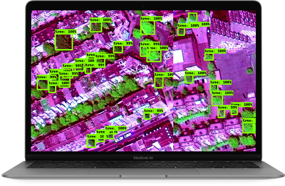
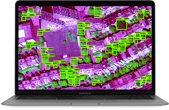
Based on these insights, the team built a solution to identify urban tree locations using object detection, a computer vision technique for detecting objects in images. Satellite spatial data was processed into GeoTIFF datasets to extract spectral band information for training machine learning models. Since tree species vary across spectral bands, multiple models were developed and combined using ensemble modeling to deliver more accurate and reliable results.
Recognizing that spectral reflections vary by region, the platform was designed to be regionally adaptive, allowing unique band combinations to be applied for accurate detection across diverse geographies. This ensured consistent accuracy for urban forestry mapping regardless of location.
Scalable AWS Cloud Infrastructure
The platform leverages AWS services such as SES, ECR, SageMaker, S3, and Lambda to support notifications, container storage and execution, data storage, and automatic scaling. This setup delivers a flexible, resilient, and cost-efficient infrastructure capable of running multiple machine learning models concurrently while maintaining high performance.
The platform provides a feature-rich user portal, empowering users to explore urban green cover, monitor tree growth, and analyze forest health:
- AI-Driven Tree Detection and Classification
Uses advanced object detection and multiple machine learning models to identify trees in satellite imagery, analyze spectral band combinations, classify species, and accurately map tree locations.
- Region-Adaptive Models for Accurate Urban Analysis
Applies region-specific machine learning models to account for differences in urban environments and spectral reflections, ensuring reliable tree detection across diverse geographic areas.
- Interactive Real-Time Mapping and Visualization
Enables users to explore urban green cover through interactive maps built with QGIS, Leaflet, Maply, and WhirlyGlobe, allowing detailed zoom, neighborhood-level analysis, and visualization of tree distribution.
- Historical Insights, Analytics, and Data Export
Tracks tree data across seasons and time to monitor growth patterns and forest health, while providing analytical dashboards and export options in GeoTIFF and other GIS-compatible formats for urban planning and reporting.
The admin portal provides comprehensive management and operational oversight:
- Model Management and Optimization
Manage, monitor, and deploy multiple machine learning models across regions and species while ensuring consistent performance and accuracy.
- Geospatial Data Pipeline Control
Oversee satellite data ingestion, GeoTIFF dataset management, and preprocessing workflows to maintain data quality and model reliability.
- Analytics, Insights, and Alerts
Access real-time dashboards for detection accuracy, species coverage, and seasonal trends, along with automated alerts for anomalies and low-confidence detections.
- Integrations and Platform Configuration
Configure integrations with external GIS tools, third-party APIs, and cloud services to extend the platform’s capabilities and support operational efficiency.
The Impact
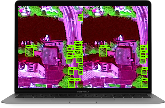
The platform provides municipalities and urban foresters with a comprehensive, real-time view of their tree inventory, enabling more informed decision-making and streamlined management of urban green spaces.
By integrating Industry 4.0 technologies, including satellites, LiDAR, and drones, TreeTect delivers actionable insights that support efficient and sustainable urban forestry practices. The solution helps cities monitor tree health, plan maintenance, and optimize green space management for long-term environmental impact.

>90%
Precision
11
Machine Learning Models Trained
30+
Cities Mapped